Image:Ftamap.PNG
From Wikipedia, the free encyclopedia

Size of this preview: 640 × 318 pixels
Full resolution (800 × 397 pixels, file size: 96 KB, MIME type: image/png)
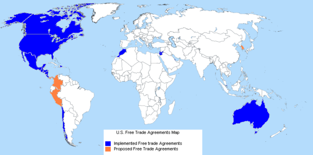
This is a map of all currently implemented as well as current prospective free trade agreements between the United States and other nations. I used the base white map from Wikipedia Commons and applied colors to it in order to denote the nations involved. This image was created on July 9-10, 2007, and it could easily be used for the articles, "United States,""Economy of the United States," or "Free Trade."
{
| |
This work is licensed under the Creative Commons Attribution-ShareAlike 2.5 License. Attribution: Brandon A. Blosser |
File history
Click on a date/time to view the file as it appeared at that time.
| Date/Time | Dimensions | User | Comment | |
|---|---|---|---|---|
| current | 09:20, 10 July 2007 | 800×397 (96 KB) | Alex1453 ( Talk | contribs) | (This is a map of all currently implemented as well as current prospective free trade agreements between the United States and other nations. I used the base white map from Wikipedia Commons and applied colors to it in order to denote the nations involved.) |
See the setup instructions for more information.
File links
The following pages on Schools Wikipedia link to this image (list may be incomplete):
Categories: Creative Commons Attribution-ShareAlike 2.5 images