Image:USGS map Albers conic tall.gif
From Wikipedia, the free encyclopedia
No higher resolution available.
USGS_map_Albers_conic_tall.gif (335 × 195 pixels, file size: 27 KB, MIME type: image/gif)
| |
This is a file from the Wikimedia Commons. The description on its description page there is shown below. |
| |
This map image was uploaded in a raster image format such as PNG, GIF, or JPEG. However, it contains information that could be stored more efficiently and/or accurately in the SVG format, as a vector graphic. If possible, please upload an SVG version of this image. After doing so, please replace all instances of the previous version throughout Wikipedia (noted under the “File links” header), tag the old version with {{ Vector version available|NewImage.svg}}, and remove this tag. For more information, see Wikipedia:Preparing images for upload. For assistance with converting to SVG, please see the Graphics Lab. |
 |
Summary
| Description |
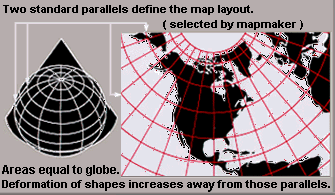
Condensed explanation of Albers conic-projection maps, rearranged as taller image, from larger, wider USGS file of GIF format. See enlarged view below, using a wikitable to expand beyond original size. |
|---|---|
| Source |
derivative from USGS image file (magnified 20%, made taller),
|
| Date |
15-November-2007 |
| Author |
User:Wikid77, rearranging US Government USGS image. |
| Permission ( Reusing this image) |
(see below) |
| Other versions |
Wider image with blurred lettering, speckles, 41% more data (PNG format): |
Enlarged view
| Explanation of Albers equal-area conic projection. |
Licensing
 |
I, the copyright holder of this work, hereby release it into the public domain. This applies worldwide. In case this is not legally possible: Afrikaans | Alemannisch | Aragonés | العربية | Asturianu | Български | Català | Cebuano | Česky | Cymraeg | Dansk | Deutsch | Eʋegbe | Ελληνικά | English | Español | Esperanto | Euskara | Estremeñu | فارسی | Français | Galego | 한국어 | हिन्दी | Hrvatski | Ido | Bahasa Indonesia | Íslenska | Italiano | עברית | Kurdî / كوردی | Latina | Lietuvių | Latviešu | Magyar | Македонски | Bahasa Melayu | Nederlands | Norsk (bokmål) | Norsk (nynorsk) | 日本語 | Polski | Português | Ripoarisch | Română | Русский | Shqip | Slovenčina | Slovenščina | Српски / Srpski | Suomi | Svenska | ไทย | Tagalog | Türkçe | Українська | Tiếng Việt | Walon | 中文(简体) | 中文(繁體) | zh-yue-hant | +/- |
| |
This image is in the public domain because it contains materials that originally came from the United States Geological Survey, an agency of the United States Department of Interior. For more information, see the official USGS copyright policy |
|
File history
Click on a date/time to view the file as it appeared at that time.
| Date/Time | Dimensions | User | Comment | |
|---|---|---|---|---|
| current | 04:36, 16 November 2007 | 335×195 (27 KB) | Wikid77 | (initial upload) |